Would you like to make this site your homepage? It's fast and easy...
Yes, Please make this my home page!
THE EFFECT OF CARBON DIOXIDE ON TORNADO ALLEY
I had to do a paper on global warming, the CO2 or some other environmental concern, and though I hate 'greener wiener' crap, I did one. This paper earned me a 77/80, or 96%.
Any citizen in the United States Midwest is familiar with tornadoes and it seems that tornado reports are increasing every year. Is this due to better technology? Is it due to increased population in tornado-prone areas? Mostly. But one cannot help but wonder if there is another missing link.
In addition to the increased tornadoes in recent years, the average citizen is becoming more and more aware of the pollution problem. Every fifth grader may not know all fifty states, but every fifth grader can explain what a Chlorofluorocarbon is and how it damages the ozone. Granted, this is a gross generalization, yet it does spawn the question: does global warming have an effect on the weather systems of the United States Midwest?
When one thinks about pollution and global warming, typically pictures of smoggy cities, melting ice caps and recycled products are conjured up in one's mind. While these are all related, one of the real issues lies in what causes global warming.
In a few words, so-called "greenhouse gasses." A common misconception is that these greenhouse gasses are unnatural, and are a result of evil, money-grubbing industry and must be avoided at all costs. This is not the case. In fact, nature itself emits tons greenhouse gasses into the air every day. Nature has even built in sinks for greenhouse gasses, should there be an unusually large natural emission. The largest natural sink is the ocean, where CO2, a common greenhouse gas is absorbed. In fact, the largest concentration of CO2 on earth is in the Earth's oceans. Trees and plants need CO2 to breathe. Volcanoes spew thousands of tons of greenhouse gasses into the atmosphere.
The important thing to notice is that CO2 and other greenhouse gasses are in a balance- a forgiving one at that. Efforts must be made to slow emissions of unnatural CO2, but it must be understood that CO2 is a natural part of life.
CO2 has some other specific properties. "CO2 transmits solar radiation but absorbs some of the outgoing long wave radiation from the Earth, which is the so-called 'greenhouse' effect. Thus, qualitatively, CO2 should act to warm the lower atmosphere and, by radiating more outgoing energy, cool the stratosphere" (Wood, 239). This is just simply building on the concept that greenhouse gasses trap solar radiation between the lower levels of the atmosphere, causing a net temperature rise. Therefore, if there was no CO2, life on Earth might be impossible. On the other too much CO2 will cause an out of control warming trend, which is where the concern lies.
The effects of global warming are not always evident. By definition, the average global temperature increases. What is not so obvious is melting ice caps, sea level rises, weather pattern changes, etc. While melting ice caps and sea level rises are beyond the scope of this paper, it will be noted that the Intergovernmental Panel of Climate Change (IPCC) reported in 1990 that sea levels will rise as much as 6 centimeters per decade (Schmandt, 5). That is not a lot of water to the District of Colombia or Topeka. It is to those who live in Amsterdam, or New Orleans, where the community is at or below sea level. One problem associated with this sea level rise is known as salt-water intrusion, where salt water makes its way farther up streams and rivers, killing scores of freshwater fish. In some third-world countries, these freshwater fish maybe the way of life. So while this is a very important issue, it will not be described in further detail in this paper.
How much does the temperature rise? The IPCC reported in 1990 that the Earth could expect a "warming of 0.3oC per decade" (Schmandt, 5). On this scenario, the temperature will raise 33oC by the year 2100! This sounds shocking, but in reality, this scenario is known as "business as usual," which means technology does not improve, no new emissions standards are passed, etc. It's almost a linearization of the current trend.
Has the warming started? Of course it has. Appendix A shows a graph of the CO2 increase in past years. "Recent studies report that the Earth was warmer in 1990 than any other year since 1880, and the ten warmest years on record occurred since 1973" (Schmandt, 5). This is a global average total. How will it affect local climates? That is a difficult question that all the meteorologists in the country with cutting edge technology cannot answer. The best that can be done is forecast, just as is done for short-term weather conditions- with a broader forecast area.
Weather patterns will be influenced by many factors including geography, prevailing upper level winds, fronts, pressure differentials and so on. However, on the average, global warming will produce significant warming trends at the poles, moderate warming at mid-latitudinal regions and surprisingly, not much change in tropical regions (Schmandt, 3). A heat versus latitude graph would show large heat absorption near the equator, and very low heat absorption at the poles- hence why the poles are cold and the tropics are hot. Global warming tends to transform this graph from a trapezoidal shape to a straight line, running at a uniform temperature, regardless of latitude. Obviously, the latter is an extreme case, but it proves its point.
Obviously, a change in temperature will bring a change in general weather. A degree of temperature difference can mean snow for one town, and a wintry mix for another. A good rise in temperature will increase evaporation. Here is where an interesting question arises. With an increase in evaporation, will more clouds, and eventually more precipitation form? Or will the evaporation be due to exceptionally low relative humidity, producing cumulus clouds with no threatening rain. According to the IPCC, the mid-latitude region will have a reduced number of thunderstorms during the summer (Schmandt, 6). Furthermore, the IPCC predicts, "less rain likely in the Mediterranean, N. Africa, American Midwest, and S. California" (Schmandt, 6). Assuming IPCC's prediction, the United States Midwest can expect drier, warmer summers and earlier springs.
During the typical spring, cold, arctic air from Canada rushes southeast across the Rocky Mountains in Colorado. At the same time, the spring weather is heating the Gulf of Mexico, causing warm, moist air to slowly migrate northwest. Typically, the cold arctic air flows in aloft. Surface convection forces some of the warm moist air upwards, causing cumulus clouds. As these convectional forces continue, the cumulus clouds grow into cumulonimbus clouds, producing thunderstorm. If these clouds still grow larger, their tops will hit the stratopause, a temperature inversion just above the stratosphere. The cloud tops will tend to flow horizontally outward from this point, becoming what meteorologists call a "super cell." Its anvil shape can readily identify a supercell, where the horizontal outflow of clouds extends past the towering cumulonimbus cloud.
Upon examining the internal structure of the super cell, one notices the great horizontal wind shear. This wind shear is driven by one air mass pushing over another in an almost opposite direction. Wind shears can be sometimes viewed as spinning, horizontal condensation from the ground on the southwest side of the storm. While wind shears are hazardous to tall buildings and aircraft, the danger therein lies when the wind shear meets a strong updraft or downdraft. In either case, the draft forces the spinning air to tighten its radius, and, by conservation of angular momentum, it must speed up. In addition to the higher speed and smaller radius, the wind shear is now tilted at an angle, or bent to an unnatural position. Precipitation at the cloud base begins to rotate, which forms what is known as a "wall cloud." Most of the time, this will be the extent of the updraft. In other unfortunate cases, the wind shear begins to make its way down past the wall cloud. Dust, precipitation, and debris begin to rotate on the surface. A tornado is born.
Typically, tornadoes form on the southwest corner of the super cell because that is where most of the wind shears are located. Another important point is that super cells are not the only storm systems that develop tornadoes, and not every super cell spawns tornadoes.
Some tornadoes may last only a few seconds, some may drag on for hours. The color of the funnel has to do with the debris that is being rotated around the low-pressure center, known as the vortex. There are stories of a tornado destroying a flower shop right before Valentine's Day, sucking thousands of red and pink roses into the funnel, giving the tornado a colorful red and pink tint.
Though tornadoes have struck during all months of the year, and have left no state untouched, the greatest concentration of tornadoes is in the United States Midwest. As discussed earlier, this area is the prime area for super cell development. In fact, "the most favorable area in the world for tornado formation is the Great Plains of North America, especially in spring and early summer. At this season, cold, dry air penetrates the region from Canada, often overriding maritime, tropical air" (Lawson, 76). Appendix B shows a map of the United States with tornado frequencies.
The United States Midwest receives so many tornadoes that it has been deemed "Tornado Alley." Tornado Alley consists of Oklahoma, Kansas, Nebraska, South Dakota, Iowa, Illinois, Missouri, Arkansas, and parts of Texas, Louisiana, and Indiana. Schools in these regions practice fire drills (like most schools in the United States), but now also practice tornado drills: what to do if a tornado warning is issued for the location of the school. However, tornado safety is beyond the scope of this paper.
There has been a new trend, however. In 1992, Ohio saw more tornadoes than in any other year (Schnidlin, 331). July alone saw 44, which was a monthly record (Schnidlin, 331). One unfortunate day, July 12, 1992, saw 28 tornadoes (Schnidlin, 331). Obviously, some freak statistics exist. Twenty-eight in one day means there was a freak super cell. There were 16 more that very same month. One storm did not do all the damage in Ohio.
There are many explanations to the causes of instances like this. Unusually high numbers of tornadoes have been seen in recent years in states east of the Mississippi River. One must consider this hypothesis.
As was mentioned earlier, global warming is most extreme at the Earth's north and south poles. As this air flows southeast over the Rocky Mountains in the spring, it still produces the same dry, cooling effect. However, because the air is slightly warmer, it will not be as unstable as cold air when it meets the moist, Gulf air. Furthermore, because it is a little warmer, it will take up a slightly larger amount of volume, covering more ground. For argument's sake, one could assume that the cool, dry air is now as far east as Ohio, as the western boundary is mostly locked because of the Rocky Mountains.
On the other hand, northern Texas and Oklahoma are receiving less and less precipitation. The summers are drier, which damages the crop production (though that is beyond the scope of this paper), the clouds that appear here will be nothing more than fluffy cumulus clouds.
The influx of heat, though only a little bit in equatorial regions, might be enough to heat to keep the Gulf Stream extra warm. This warmer Gulf Stream, which flows northeast along the United States eastern coastline will act to provide its own stronger maritime tropical air mass. This air mass will not be as strong as the one coming in off the Gulf of Mexico, but its effects must be considered.
The end product is this: now there is a convergence zone of cooler Canadian air, and warmer Gulf Stream air over Indiana, Ohio, Tennessee, and Kentucky, forming a minor "Tornado Alley." Also, the drier air in Oklahoma and Texas will dry out conditions and actually lower the local probability of super cells, and thus, tornadoes.
While this idea seems far-fetched, it is highly possible. The extreme result is Tornado Alley being shifted slightly east and now stretching longitudinally from Kansas and Nebraska to Pennsylvania, Virginia and the Carolinas. By the time the effects on Tornado Alley are this great, however, the real ecological problems of global warming will already be felt.
Though it is hard to predict the long-term effects of pollution, it would be wise for the inhabitants of Earth to follow as closely as possible the delicate balance nature has prepared. If not, conditions could get unfavorable to support human life.
Appendix A
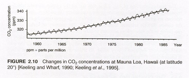
Source: The Carbon Dioxide Problem, Page 48
Appendix B
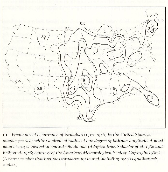
Source: Tornado Alley, 7
WORKS CITED
Bluestein, Howard B., Tornado Alley.  Oxford University Press, Oxford, 1999.

Kojima, Toshinori,  The Carbon Dioxide Problem.  Ed. Brian Harrison.  Gordon and
	Breach Science Publishers, Chou University, Japan, 1994.

Lawson, Merlin P, Kenneth F. Dewey and Ralph E. Neild.  Climatic Atlas of Nebraska.
	University of Nebraska Press, Lincoln, 1977.

Schmandt, Jurgen and Judith Clarkson.  The Regions and Global Warming.  Oxford
	University, Oxford, 1992.

Schnidlin, Thomas W, and Jeanne Appelhans Schmidlin.  Thunder In the Heartland.
	Kent State University, Kent, 1996.

Wood, Dr. Richard A.  The Weather Almanac.  Gale Research, Detroit, 1998.
Return to Weather Page
Return to Seth's Home Page